Property List > 00000005112
Property List
> 愛知県
> 00000005112
土地建物 愛知県稲沢市平和町塩川 265番地
00000005112 / 名古屋地方裁判所一宮支部 / 令和07年(ケ)第34号
Sold
79 views
Source: BIT (Real Estate Auction Information Site)
🤖 AI Document Analysis
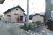
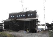
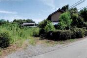
This property comprises land in an Urbanization Control Area and two severely dilapidated buildings (one with numerous unregistered extensions). The land is occupied under a gratuitous loan between relatives, potentially leading to delays and costs in obtaining vacant possession. Significant investment risks include construction restrictions, unregistered structures, severe dilapidation, unclear infrastructure status, and potential asbestos.
🏠
Occupancy
Owner
🚨
Risk Score
5/5
🔧
Condition
Deteriorated
🏗
Rebuild
Not Possible
Risk Factors:
市街化調整区域に指定されており、建築行為に厳しい制限がある。物件2の主たる建物および附属建物に多数の未登記増築部分が存在し、違法建築の可能性がある。物件2および附属建物は著しく老朽化しており、大規模な修繕または解体が必要となる可能性が高い。土地の占有権原が親族間の使用借権であり、明渡しに時間や費用がかかる可能性がある。境界の一部が不明確であり、隣地からの引込柱越境の可能性もあるため、境界確定に問題が生じる可能性がある。供給処理施設(水道、ガス、下水)の状況が不明確で、物件2のトイレは汲取式であり、インフラ整備に費用がかかる可能性がある。建築年からアスベスト含有建材が使用されている可能性があり、解体費用が増大するリスクがある。物件の一部が農地であるため、買受資格が制限される。洪水リスクが0.5~3m未満と推定されており、自然災害のリスクがある。
Legal Issues:
市街化調整区域に指定されており、建築確認や再建築、大規模な増改築には行政庁との事前協議と許可が必要となる。物件2の主たる建物および附属建物に多数の未登記増築部分が存在し、建築基準法等に違反している可能性がある。土地の占有権原が親族間の使用借権であり、買受人が占有者に対して明渡しを求める際に、交渉や訴訟に発展する可能性がある。隣地からの引込柱が物件1土地に越境している可能性があり、境界確定や越境物撤去に関する問題が生じる可能性がある。物件の一部が農地であるため、買受申出には農地法上の制限がある。
AI auto-analysis. Always verify with original Three-Document Set before investing.
Sale Result
Base
2,1240K ¥
Won
1,7110K ¥
Diff. +-4130K ¥
0.81x
Bidders
1
Sale Date
2026-04-22
Yield on Winning Bid
25.9%
Base20.9%
Base Price
2,1240K ¥
Base
Land
Land ratio65% Undervalued
Area
369.7m²
111.8 tsubo
Gross Yield
20.9%
0%7%10%15%20%
Nearest Station
六輪
Walk7 min (591m)
Analysis Data
Land Valuation
Official Land Price110,000 ¥/m²
Road Rate (Est.)88,000 ¥/m²
Price per Tsubo290,909 ¥/tsubo
Total Land Value32,531,840 ¥
Base
2,1240K
Land
3,2530K
Land ratio65%
Undervalued
Transportation Access
Nearest Station六輪
Distance591m (7 min walk)
Line名古屋鉄道
Walking Distance
Hazard Information
Elevation1.0m
Flood Risk
Very High
Landslide Risk
Low
Map
Price History
21 records| Date | Base Price | Yield | Change |
|---|---|---|---|
| 2026-04-22 | 2,124k | 20.9% | — |
| 2026-04-14 | 2,124k | 20.9% | — |
| 2026-04-13 | 2,124k | 20.9% | — |
| 2026-04-12 | 2,124k | 20.9% | — |
Property Info
| Bid Deadline | 2026-04-15 |
|---|---|
| Status | Sold |
| Prefecture | 愛知県 |
| City | 稲沢市 |
| Winning Bid | 17,111,119 ¥ (deviation -19.4%) |
| Bidders | 1 |
| Lat/Lng | 35.1982, 136.7334 |
| Data Updated | 2026-04-14 18:11 |
| Analysis Date | 2026-03-24 18:53 |
| Detail Fetched | 2026-03-24 18:31 |
愛知県 Market Data (81 properties)
This
20.9%
Pref. Avg.
19.1%
+1.8pt Above Average
Property Details (BIT)
Building Info
Built
平成20年3月 (Age cons. 82%)
Rental Demand
19/25
★★★☆☆
Structure
木造かわらぶき平家建
Type (Registered)
居宅
Floor Plan
11室+土間+物置等
Total Floor Area
573.95m²
Rights & Fees
Registered Area
1632.19m²
Land Rights
所有権
Occupant
債務者・所有者
Regulations & Bid Info
Zoning
市街化調整区域
Coverage Ratio
60%
Floor Area Ratio
200%
Deposit Required
4250K ¥
Min Acceptable
1,6990K ¥
Bid Opening
2026-04-22
Sale Decision Date
2026-05-13
📤 Share this property
Similar Properties

土地建物
43.2%
3,150,000 ¥
愛知県稲沢市祖父江町山崎舟橋 297番地4
土地建物
7.1%
21,130,000 ¥
愛知県東海市養父町浅間前 17番地1

土地建物
41.6%
3,460,000 ¥
愛知県新城市富栄字貝津田14番地2、14番地1、11番地1
土地建物
11.4%
10,040,000 ¥
愛知県豊橋市石巻本町字的場 63番地3、63番地1、63番地2
Related Articles
Property Analysis Report
Download a PDF report with AI risk score, yield analysis, and hazard evaluation. Free to use for financing consultations.
Three-Document Set (Property Details, Site Survey Report, Appraisal)
The Three-Document Set PDF is saved on our site. You can view it even after BIT listing ends.
Source: BIT (Real Estate Auction Information Site) https://www.bit.courts.go.jp