Property List > 00000023266
Property List
> 愛知県
> 00000023266
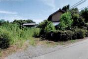
土地建物 愛知県名古屋市守山区西城一丁目 120番地、118番地、119番地
00000023266 / 名古屋地方裁判所本庁 / 令和07年(ケ)第248号
Sold
79 views
Source: BIT (Real Estate Auction Information Site)
🤖 AI Document Analysis
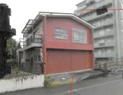
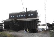
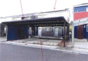
Property 4 is a 51-year-old deteriorated residence with potential damage to its foundation and structure, and unknown compliance with new seismic standards. The land is sloping and potentially subject to cliff ordinances, with unknown safety compliance of its retaining walls. An unregistered basement area exists, and residual items are present in the building, requiring the buyer to incur additional costs and legal procedures.
🏠
Occupancy
Owner
🚨
Risk Score
4/5
🔧
Condition
Deteriorated
🏗
Rebuild
Not Possible
Risk Factors:
建物は築51年の老朽化物件であり、基礎及び躯体に損傷が生じている可能性が高い。新耐震基準への適合が不明であり、耐震改修の必要性が生じる可能性がある。アスベスト含有建材が使用されている可能性があり、解体・改修時に特別な費用が発生する。地下1階に約9.5㎡の未登記部分が存在し、登記手続きが必要となる。土地は傾斜地で「がけ条例」の規制対象となる可能性があり、建築制限や追加工事費用が発生する。擁壁の一部にひび割れがあり、法令上の安全基準を満たしているか不明で、補修・再構築費用が発生する可能性がある。建物内に残置物があり、買受人が搬出・廃棄費用を負担する必要がある。北側道路は階段状で自動車の通行が不可能であり、アクセスに制約がある。
Legal Issues:
地下1階に約9.5㎡の未登記部分が存在し、登記手続きが必要。土地が「がけ条例」の規制対象となる可能性があり、建築基準法上の制限を受ける。擁壁の安全基準適合性が不明であり、行政指導や補修・再構築の義務が生じる可能性。アスベスト含有建材使用の可能性があり、関連法規に基づく適切な処理が必要。新耐震基準への適合が不明であり、将来的な耐震改修義務や費用が発生する可能性。
AI auto-analysis. Always verify with original Three-Document Set before investing.
Sale Result
Base
1,3240K ¥
Won
1,4240K ¥
Diff. +1000K ¥
1.08x
Bidders
2
Sale Date
2026-04-22
Yield on Winning Bid
15.9%
Base17.1%
Base Price
1,3240K ¥
Base
Land
Land ratio42% Undervalued
Area
188.2m²
56.9 tsubo
Gross Yield
17.1%
0%7%10%15%20%
Nearest Station
瓢箪山
Walk7 min (579m)
Analysis Data
Land Valuation
Official Land Price210,000 ¥/m²
Road Rate (Est.)168,000 ¥/m²
Price per Tsubo555,371 ¥/tsubo
Total Land Value31,617,600 ¥
Base
1,3240K
Land
3,1620K
Land ratio42%
Undervalued
Demographics (Census)
Municipal Population2,320,361
Pop. Growth (5yr)
+1.0%
Growing
-10%0%+10%
Transportation Access
Nearest Station瓢箪山
Distance579m (7 min walk)
Line名古屋鉄道
Walking Distance
Hazard Information
Elevation19.6m
Flood Risk
Low
Landslide Risk
Low
Map
Price History
21 records| Date | Base Price | Yield | Change |
|---|---|---|---|
| 2026-04-22 | 1,324k | 17.1% | — |
| 2026-04-14 | 1,324k | 17.1% | — |
| 2026-04-13 | 1,324k | 17.1% | — |
| 2026-04-12 | 1,324k | 17.1% | — |
Property Info
| Bid Deadline | 2026-04-15 |
|---|---|
| Status | Sold |
| Prefecture | 愛知県 |
| City | 名古屋市 |
| Winning Bid | 14,241,000 ¥ (deviation +7.6%) |
| Bidders | 2 |
| Lat/Lng | 35.2023, 136.9629 |
| Data Updated | 2026-04-14 18:11 |
| Analysis Date | 2026-03-20 13:12 |
| Detail Fetched | 2026-03-24 18:28 |
愛知県 Market Data (81 properties)
This
17.1%
Pref. Avg.
19.1%
-2.0pt Below Average
Property Details (BIT)
Building Info
Built
昭和49年12月 (Age cons. 236%)
Rental Demand
19/25
★★★☆☆
Structure
鉄骨造スレート葺地下1階付2階建
Type (Registered)
居宅
Floor Plan
2LDK+倉庫+物置
Total Floor Area
366.90m²
Rights & Fees
Registered Area
35.65m²
Land Rights
所有権
Occupant
債務者・所有者
Regulations & Bid Info
Zoning
第一種住居地域
Coverage Ratio
60%
Floor Area Ratio
200%
Deposit Required
2650K ¥
Min Acceptable
1,0590K ¥
Bid Opening
2026-04-22
Sale Decision Date
2026-05-13
📤 Share this property
Similar Properties

土地建物
41.6%
3,460,000 ¥
愛知県新城市富栄字貝津田14番地2、14番地1、11番地1
土地建物
11.4%
10,040,000 ¥
愛知県豊橋市石巻本町字的場 63番地3、63番地1、63番地2
土地建物
7.1%
21,130,000 ¥
愛知県東海市養父町浅間前 17番地1
土地建物
10.7%
11,240,000 ¥
愛知県犬山市字稲干場 17番地117
Related Articles
Property Analysis Report
Download a PDF report with AI risk score, yield analysis, and hazard evaluation. Free to use for financing consultations.
Three-Document Set (Property Details, Site Survey Report, Appraisal)
The Three-Document Set PDF is saved on our site. You can view it even after BIT listing ends.
Source: BIT (Real Estate Auction Information Site) https://www.bit.courts.go.jp